

O NÁS
ÚVOD
KONTAKTY
POVZBUZENÍ OD DĚDEČKA
LEDOVÉ ŠÍLENSTVÍ
UŽITEČNĚ STRÁVENÁ SOBOTA
SVÍTÍCÍ KRÁPNÍKY
OWENSKÁ ZÁHADA
OBŘÍ DŮL-GEOLOGICKÁ
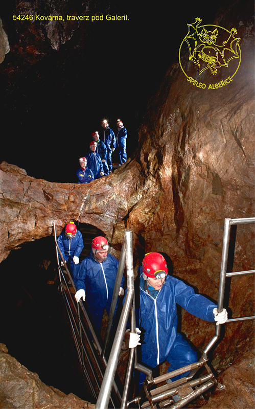
EXPOZICE KOVÁRNA
TURISTICKÝ PROVOZ
ZÁKLADNÍ INFORMACE
BASIC INFORMATION
ZAHÁJENÍ PROJEKTU
ZMÁHÁNÍ ŠTOLY PROKOP
SKALNÍ ÚSEK ŠTOLY PROKOP
KONSTRUKCE V TÉTO ŠTOLE
UKONČENÍ PROJEKTU
FILMY
FOTOGRAFIE
ODBORNÉ ČLÁNKY
ALBEŘICKÁ JESKYNĚ
ZÁKLADNÍ INFORMACE
BASIC INFORMATION
FILMY
FOTOGRAFIE
PHOTOS
ODBORNÉ ČLÁNKY
ALBEŘICE
FOTOGRAFIE
CELNÍ JESKYNĚ
ZÁKLADNÍ INFORMACE
HISTORICKÉ FOTOGRAFIE
ODBORNÉ ČLÁNKY
JESKYNĚ TRUCOVNA
ZÁKLADNÍ INFORMACE
ODBORNÉ ČLÁNKY
KRAKONOŠOVA JESKYNĚ
ZÁKLADNÍ INFORMACE
FOTOGRAFIE
ODBORNÉ ČLÁNKY
MEDVĚDÍ JESKYNĚ
ZÁKLADNÍ INFORMACE
ODBORNÉ ČLÁNKY
HISTORICKÉ FOTOGRAFIE
SPELEOLOG 1. STUPNĚ
KONGRES 1989 BUDAPEŠŤ
SPELEOSETKÁNÍ 1982
SPELEOSETKÁNÍ 1986
1. VS ČSS 1990
JOSEFOVSKÁ STOKA II.
LOUČEŇ -STOKY
EXPEDICE KRN 85
SPELEOFÓRUM 85
PUBLIKAČNÍ ČINNOST
SEZNAM PUBLIKACÍ
ODBORNÉ ČLÁNKY
 |
 |
The deposit of Obří důl is ranked within the group of base-metal skarns. It comprises two bigger and one smaller mineralized bodies, designated as the Helena, Gustav and Václav lenses. Besides these ore lenses, the deposit also contains other minor bodies which were subjected to prospection works in the past and possibly also to small-scale mining.
The deposit of Obří důl is ranked within the group of base-metal skarns. It comprises two bigger and one smaller mineralized bodies, designated as the Helena, Gustav and Václav lenses. Besides these ore lenses, the deposit also contains other minor bodies which were subjected to prospection works in the past and possibly also to small-scale mining.
The mineralized bodies have complex cylindrical and lenticular geometries dipping steeply downwards. They are dominated by older sulphidic mineralization and younger scheelite mineralization. Younger mineralization has been as yet documented only in the Helena Lens, which lies directly at the contact with granite.
The lenses are composed mostly of skarns and calc-silicate rocks, although cherts, amphibolites and relics of mica schists are also present. They are hosted by a body of crystalline limestones to crystalline calcareous dolomites. These carbonate rocks are locally present also in thin beds folded within the mineralized bodies. The deposit is surrounded largely by mica schists, gneisses and cherts, with rocks of the Krkonoše-Jizera pluton adjoining in the north. The mineralized lenses themselves are not cut by major faults, and a notable fault striking approx. NE-SW is present only between the Helena Lens and the Gustav Lens. Crystalline limestones along this fault are karstified to form irregular, narrow channels draining a lot of water, although instable cavities several metres in size are also present.
Sulphidic mineralization dominated by pyrrhotite, arsenopyrite and chalcopyrite has the form of disseminations, tiny veinlets and especially in accumulations. It is present primarily in calc-silicate rocks, skarns, amphibolites and - to a lesser degree - has been lately found also in quartzites and mica schists. Unexploited accumulations of massive sulphidic ores with different, mutually variable proportions of pyrrhotite and arsenopyrite, and subordinate contents of chalcopyrite have been preserved in historical mine workings in volumes of max. 0.25 m³ at several sites. Massive accumulations of chalcopyrite have been hitherto found in only smaller volumes; however, accumulations comparable to those of pyrrhotite and arsenopyrite in volume must have almost certainly existed too.
Accumulations of massive sulphidic ores were the primary target of mining. Rocks with minute ore disseminations and tiny veinlets were left untouched, as visible in the walls of the mine workings. Numerous boulders of pyrrhotite were left directly in the mine workings, evidencing that first sorting took place directly under the ground. Second sorting took place on the surface (e.g., in the so-called Erzscheide Kaue located near the entrance to the Barbora Adit), as evidenced by the high contents of pyrrhotite directly on spoil tips or their margins and also by archival records on the Riesenhain smelter from the 19th century.
Based on various reports, which are difficult to verify, mining in the Obří důl Valley reaches far back in history. The first brief report of 1511 mentioned miners who came to work in the Obří důl Valley after their failure in Trutnov. The mine they opened and the extent of possible mining remain unknown. In the first half of the 16th century, Christoph Gendorf from Carinthia undertook mining in the Vrchlabí area (Lánov, Herlíkovice), especially that of iron ore, and gold mining at Černý Důl. His activities in the Obří důl Valley are also occasionally reported. This is in some contradiction with the report of 1534, in which a mining enterprise of seventeen entrepreneurs asked for a 12-years' mining lease in the Obří důl Valley. No consent with mining was probably issued due to the negative statement of supreme mint master Christoph Gendorf, who was holding the position of mining sheriff. His negative statement can be possibly explained by his fear from a competition to his own mines.
Then, the objects of primary interest in the Obří důl Valley were arsenopyrite and chalcopyrite. Occasional mining of silver can be neither excluded: although it was mentioned in 1548, it can be documented neither historically nor geologically. At that time, the Krkonoše Mountains and the Obří důl Valley in particular were visited by prospectors of precious stones. These stones also included crystal quartz and fluorite, which were present in sufficient amounts in the Obří důl Valley. This laid the foundations of various legends and fairy tales about treasures hidden under the ground and about the many who found their riches in the Krkonoše Mountains.
Several mining objects are drawn on the map by Jiřík of Řásná, a mine surveyor and engraver of coining dies from Kutná Hora (the presumed Hütel map), probably from 1569. The map, however, provides no information as to the extent of mining or the locations of the mine workings. Thick deposits of copper and lead ores were discovered by mining entrepreneur and prospector Hanse Seyfert in 1569. Again, silver ores are also mentioned. The first drawing of a hut used chiefly for the maintenance of mining tools comes from the year 1568. Its location is not known: either at the future site of the Kovárna Hut (Smithy) built some time after 1828, or at Rudník showing traces after old mining in the field.
In the 1660s, operation of the mines was financed by the owner of the Maršov area Jakub de Waggi. After his death in the early 18th century, mining was conducted by another owner of the dominium, Berthold Vilém Valdštejn. The mines are, however, less profitable, and information from these centuries is relatively scarce and not quite reliable. Most probably, copper and arsenic ores were extracted. Reliable evidence relates especially to mining of chalcopyrite, which was processed in situ. "Copper stone" - matte - can be found in the field but no smelting furnace could be unfortunately localized yet.
Mining of iron ores has been situated to the Obří důl Valley by some historians. Elevated amounts of magnetite have been, however, indicated only in the Zelený důl Valley and at the transition between the Růžový and Obří důl valleys. Despite the presence of magnetite as a mineral in the head of the Obří důl Valley, no economic amounts have been proved. The valley does neither host any other iron ores suitable for easy iron production in economic concentrations.
Operation of the Kovárna Mine is closely associated with the smelter at Pec pod Sněžkou, which was stretched across the Bukové Valley between the Úpa River and the steep right-bank slope at the site of the present entrance to the "U kapličky" parking lot. The company constituted in 1828 was run by a group of factors. The most important majority factors and holders of mining rights were Friedrich Winkler, a merchant from z Landeshut in Silesia, and Gustav Heinrich Ruffer from Wrocław. The latter became the main factor in 1836 and the singular owner of the company and its claims in years 1855/1856.
Exploitation through the mine workings of Heinrich, Gustav, Barbora, Prokop and Mezipatro, the sum of which is now called the Kovárna Mine, commenced at about 1813, although the presence of a small mine of inferior importance at the Gustav Lens cannot be entirely excluded. The highest prosperity of the smelters, however, dates approximately to the interval of 1828-1868, during which the smelter produced 1,250,368 kg of arsenic and 39,200 kg of raw copper. In these years, it was the only smelter in Bohemia producing both raw copper and arsenic, which gave it a privileged position in Bohemia of this time.
The most significant source of ores for the smelter was the Gustav Lens with the Kovárna Mine. Nevertheless, a progressive exhaustion of the deposit with increasing depth induced a shift of the principal mining activity to Horní Malá Úpa (Žacléřské Huts, Smrčí) in the last years of the smelter operation. Several claims in this area were also possessed by the company. Several mine workings were also operated at the Helena Lens at Rudník but the extent of local mines was considerably smaller compared to the Kovárna Mine.
One report is of significance from the geological point of view: lead ores were extracted here in May to July 1847. Only a few tons were produced according to archival data. The exact site of lead extraction within the Kovárna Mine remains unfortunately unknown. Anyway, such report proves that these ores could really be occasionally mined here in the 17th and 18th centuries.
The Kovárna Mine, the biggest workings of which are now open to the public, is more or less an extensive, steeply inclined worked-out cavity with a number of chamber-like workings of irregular shapes following the ore mineralization. Rock pillars and ore-in-places are very frequent in the workings. The thickness of the ceilings and the walls between the workings is highly variable, locally as small as only 30-40 cm.
The largest excavated chamber is called The Three Bridges Chamber after three perfectly preserved horizontal ore-in-places of rock. Their perfection is enhanced when viewed from the height of 6 m - from the rock sill called The Gallery, representing a relict of an old prospect entry. Vertical dimension of the chamber as observed by the visitors is about 10 metres, but around 20 metres in reality.
The first hereditary adit, the Barbora Adit, driven in years 1827-1831, enters the workings at a depth of 24 m. Now, it is used as an entrance for the visitors. At Mezipatro, which was driven in years 1952-1955 and which intersects old mine workings at several places, the mine reaches a depth of about 50 metres. This is the level to which the visitors descend using stainless-steel ladders with guards, following a trail winding through the main parts of the mine workings.
Overhand stoping can be observed in several chambers but the whole mine in general was stoped by underhand technique. The mine preserves old prospect adits and adits for preparation of mining several metres long. Relics of these adits (mostly headings) are preserved in the walls of the mine workings.
Some entries below the level where the Barbora Adit joins the Kovárna Mine are filled with water. As suggested by their vertical distribution and their regular positions in the closest proximity of bigger mine workings, some of the entries could have been used, after the end of their operation, as sumps for the collection of water and its pumping to the surface yet before the hereditary Prokop Adit has been driven.
The mine was excavated and advanced with no timbering. Chock and obliquely constructed byats were installed only in the upper portions of the Heinrich pit, probably not before several pillars had been blasted in the last years of mine operation. Many places in the mine featured large wooden decks of various sizes with remains of windlasses, single-step ladders chiselled from logs and a bridge across the working.
Unfortunately, wooden casing was in a very poor state and, with the exception of a few sites, had to be removed during the restoration works. Blasting employed gunpowder in the 19th century. Blastholes 20-22 mm in diameter and up to 40 cm in length were drilled manually using simple chisel bits. Traces after drilling are preserved in enormous numbers in the walls of the mine workings, including several misfires.
The downward continuation of the Kovárna Mine below the Mezipatro level was cross-cut by a level of modern (1952-1959) exploratory works at three sites, and backfilled in two cases. The only preserved original continuation and the present interconnection of the Mezipatro level with the original hereditary Prokop Adit is a steep inclined shaft, which was used as a chute way with a manway during the exploratory works.
The Mezipatro mine working at a depth of ca. 50 m is of typical trapezoidal cross section about 3.25 m2 in area. It features mine rails, turntables, a mine cart, relics of the ventilation system and a variety of tools and minor technologies. Also, the original labelling of channel samples from the times of geological exploration is visible here. The visitor trail ends at Mezipatro and the visitors return by following the same trail back to the Barbora Adit and to the surface.
The hereditary Prokop Adit was driven in years 1835-1844, but was re-driven to its typical trapezoidal cross section during the exploratory mine works in 1952-1959. Traces of old driving have been preserved at only a few places in the ceiling and inside the raise. Mining in the 19th century proceeded yet a few metres below the level of the hereditary adit but these excavations were backfilled during mine works in the 20th century. The hitherto surveyed spaces of the Kovárna Mine driven in the years of peak mining prosperity in the 19th century exceed 400 m in length and reach about 80 m in depth.
Extensive mine works aimed at a revision of tin and copper ore reserves were conducted in the terminal part of the Obří důl Valley in 1952-1959. Younger tungsten mineralization (scheelite) was also explored. The exploratory works included driving of mine workings over 7 km in total length. The total calculated tungsten reserves amounted at 100,000 tonnes. Besides, the reserves of copper ore were calculated at 856,000 tonnes (with grade of 0.41-0.43 % Cu, 0.19-0.49 % Sn and 21.4-22.46 % S. No mining claim has been ever established at the deposit, and the deposit was eliminated from the state reserves budget.
All technological equipment was left in the exploratory workings, including the winding system with a cage in the blind shaft. Only the mine locomotive was carried away. The individual openings of adits and raises were walled, grated or blasted. The Prokop Adit was, unfortunately, blasted along the whole of its course in the weathering products, i.e., along a distance of over 90 metres. At present, works aimed at its re-opening are under way.
This text was intended for the book: Zelenka J., Živor R. 2019: Mining monuments of the Czech Republic - 659 pages. Academia. Although the book was published, the authorship of this text was attributed to Mr. J. Zelenka. This way, the text got stolen.
Radko Tásler, ZO 5-02, Speleo Albeřice
| [ previous ] [ home ] | © webmaster 12.06.2024 |